8.3-mile paved, shared-use path from Northampton to Belchertown.

Explore History and Nature on the MCRT Norwottuck Branch
Route Description
The MCRT Norwottuck Branch is an 11-mile paved shared-use path stretching from downtown Northampton to Belchertown. The Department of Conservation and Recreation (DCR) manages the trail. This is mile 0 - the beginning of the 104-mile Mass Central Rail Trail. Following a “trunkline” of the former Central Massachusetts Branch of the Boston & Maine Railroad, the route passes through farmland, over the Connecticut River, and alongside swamp lands, offering abundant opportunities for wildlife-watching. Located in the heart of the Five Colleges region—Amherst, Hampshire, Mount Holyoke, Smith, and UMass Amherst—the trail connects to cultural attractions, museums, and additional paths, including the Northampton Bikeway, the New Haven & Northampton Canal Greenway, the Manhan Rail Trail, and the Robert Frost footpath.
The trail’s name honors the Norwottuck, a band of the indigenous Pocumtuck people, whose homeland encompassed this section of the Connecticut River Valley. The name comes from an Eastern Algonquian language and is often translated as “in the midst of the river,” reflecting the valley’s fertile floodplains and river bends.
This route was one of the 10 signature rides featured in the MassTrails10.
The Route
This 8.3-mile route starts in Northampton and ends in Amherst, providing a pleasant connection between two bustling college towns. If you are looking for additional miles, continue on the trail until its eastern end in Belchertown (and optionally take the trail all the way back to Northampton for a 24-mile out-and-back ride).
Mile
0.0 - Begin at the Roundhouse Plaza in Northampton
0.1 - Turn left onto Old S St., then right onto the MCRT
2.0 - Norwottuck Rail Trail Bridge
2.0 - Connecticut River Greenway State Park
3.7 - Beautiful boardwalk secction in Hadley
7.9 - Turn left onto South Pleasant Street
8.2 - Turn right onto Quadrangle Drive, then left onto Boltwood Ave.
8.3 - The ride ends at the Amherst College Bus Stop
Additional Information
Parking
You can access the trail from a number of parking lots in downtown Northampton. Your route length will vary based on the transit service stop or parking lot you begin at.
Bike Share
If you don’t want to bring your own bike, ValleyBike offers easy, affordable bikeshare service with several dock options to pick up and drop off a bike in Northampton and Amherst. Some docks around the trail are shown on the map below but download the app to view the whole system and to rent bikes.
Transportation
This ride is designed to be accessible by Pioneer Valley Transit Authority (PVTA) bus service (from Springfield, Northampton, Worcester, or Amherst), Peter Pan Bus Service, or Amtrak train service along the Vermonter and Valley Flyer routes (via Springfield, Holyoke, or Greenfield). All PVTA routes are operating fare-free at time of publishing but check their website for up-to-date information. PVTA also provides information about bringing bikes on the bus.
A map of this route can also be explored on the Mass Trail Tracker - https://masstrailtracker.com/map?segment=229
Why this is an essential MCRT route

Northampton marks the beginning of the 104-mile MCRT corridor spanning all the way to Boston. It is also a vibrant college town rich in cultural, artistic, academic and business resources.
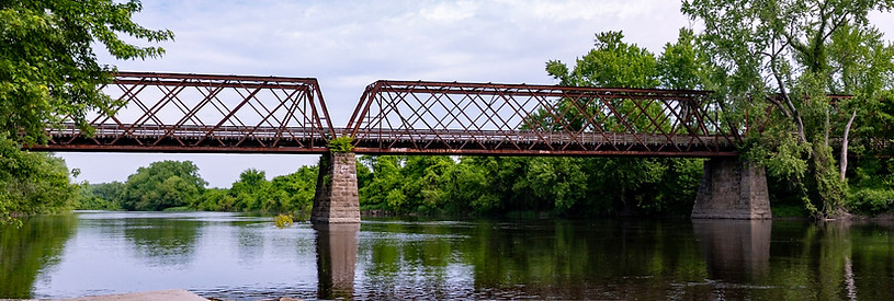
The Norwottuck Rail Trail Bridge.
This stunning, quarter-mile long bridge was the former railroad bridge that carried the Boston & Maine Railroad over the Connecticut River. Originally constructed in 1887, the bridge was redesigned, rebuilt, and re-opened as the Norwottuck Rail Trail Bridge in 1992. The bridge is also referred to as the Northampton Lattice Truss Bridge, due to its design as a steel lattice truss.

This new boardwalk section of the MCRT in Hadley connects the Hadley Middle School to the trail along River Drive and over wetland areas. This is a key part of the ongoing MCRT development in Hadley, creating accessible, year-round paths over wet sections, similar to boardwalks on other sections of the trail system
Connecticut River Greenway State Park, Elwell Recreation Area
The entire Connecticut River Greenway State Park offers 12 miles of protected shoreline, acquired over a 20-year period. At Elwell Recreation Area, there is a wheelchair-accessible dock, and rowing and canoeing are allowed.
