West Boylston and Holden 12.6 mile out and back on stonedust paved shared-use path.
Very gradual hills with a few short, moderately steep areas.

Tour Along the Quinapoxet
Route Description
This tour takes you through pristine woodlands in the Wachusett Reservoir watershed, a main source of water for the metro Boston area. Next to you is the Quinapoxet River, a clear stream that flows around boulders and over rapids. There are plenty of locations for a stop along the route to see the sights, including two trail bridges that cross the river. Wachusett Greenways constructs and maintains the central portion of the MCRT through Holden and West Boylston in partnership with the DCR, DWSP, eight Towns and others.
The Route
Start at the Thomas Street parking lot (155-159 Thomas Street West Boylston, MA)
Mile
0.0 - Thomas Street parking lot
0.1 - Trail from parking lot to MCRT, turn right,
Quinapoxet River on the left
1.2 - Cross underneath I-90 (the only noisy place
along the route)
1.4 - Springdale Mills
1.8 - First of 2 bridges over the Quinapoxet River constructed by Wachusett Greenways.
2.6 - Second of 2 bridges over the Quinapoxet River constructed by Wachusett Greenways.
2.8 - Mill Street parking lot – porta-potty and picnic table.
3.0 - Overlook high over Quinapoxet River.
3.6 - Shaft #2 of the Quabbin Aqueduct.
3.7 - Cross Manning Street and continue on the MCRT (caution – busy road)
6.0 – Turn around at Wachusett Street and head back on the MCRT.
A store and candy shop are located about a half mile south on the street – but this is a busy road, limited shoulders and uneven pavement.
Additional Information
Parking
174 Thomas Street, West Boylston
River St. Holden signed MCRT entrance (just beyond 300 River St. horse farm)
Manning St., Holden ~#170 (42.38260, -71.83856)
Accessible portable restrooms year-round at Thomas St. and River St., and at the Springdale Mill Site on the MCRT from May-Nov.
Why this is an essential MCRT route
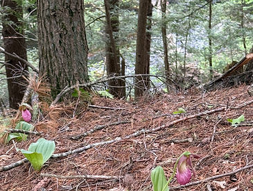
Spring brings rare lady slippers and lilies of the valley, and other wildflowers along the trail.
The Springdale Mill Interpretive Site for a once bustling woolen mill is here between the Quinapoxet River and the old Mass Central Rail line. Follow the foot trail through the mill site and uphill to the mill worker tenement foundations. Granite pillars with interpretive signs guide the way. Or visit here for a self-guided tour.


Just before crossing Manning Street, on the right is a large vent for the Quabbin Aqueduct, one of the longest underground aqueducts in the world, supplying over 500 million gallons of water to the Boston area each day.
From Manning Street, the MCRT navigates a hill with a series of gentle switchbacks and long sweeping turns that bring riders 2.3 miles west to Wachusett Street (Route 31).
