Also Boston Harbor, Alewife Brook and the Mystic River
15-mile loop beginning in Davis Square Somerville
Relatively flat, paved trail

Explore Somerville and Cambridge - traffic free
Route Description
This 15-mile urban cycling circuit ride starts (and ends) in Davis Square, the principal commercial center of Somerville that the MCRT passes right through as the Somerville Community Path. Cycling counterclockwise, after the MCRT ends near North Station, you’ll pass through Charlestown and view the USS Constitution, Boston Harbor, follow the Mystic River to Medford, and then Alewife Brook until you intersect the MCRT again and the Minuteman Bikeway at the Alewife T station.
The Route
Mile
0.0 - Start at Davis Square, this is the beginning and the end of the route.
1.0 - Gilman Sq. and new Somerville High School.
3.0 - Lechmere station and Cambridge Crossing.
4.0 - Charlestown Navy Yard.
5.0 - Assembly mixed use development, Orange line station and Mystic river parks.
8.0 - Medford Square.
9-11 - Following Alewife Brook.
12.0 - Alewife Red Line station and MCRT.
15.0 - Return to Davis Square, Somerville
Additional Information
Arrive in Davis Square by Blue Bike (shared bike system with ~30 stations on or very close to this route), your own bike, or Red Line subway (Davis Sq. stop) on the MBTA. Coming by car, there are municipal parking lots on Buena Vista and Day streets. One could also park at the Alewife Garage at the end of the Red Line subway and start cycling from there.
Why this is an essential MCRT route
0.0 miles - Davis Square, Somerville (MBTA Red Line subway stop). The ride begins in the triangle urban park in front of JP Licks Ice Cream (open all year). Many other retail businesses, including the Somerville Theatre, bars and restaurants can be found here.


Leaving the park Eastbound, cross College Ave. and walk your bike along the busway with the subway entrance on the left until you reach a parking lot and eventually the dedicated multi-use Community Path (MCRT) with a Community Garden on the left (0.2 miles). Keep your eyes peeled for sculptures by a local "gorilla" artist and relocated “Elfland”.


0.5 miles - pass Lexington St. playground on your right. If you look at the play structure, you’ll know what was formerly here: this beautiful granite RR station.


You are now at the most used section of the MCRT in Somerville, averaging 4,800 users per day in the summer (and still 1,900 in the winter) at one counting location.
0.6 miles - Crossing Cedar St., look out for more sculptures and then a 175-apartment complex built directly on the Path. Need breakfast or lunch a block away?


0.9 miles - At Lowell St., with a switchback and underpass, the Path joins the MBTA Green Line corridor as a rail w/trail. The Magoun Sq. Green Line light rail station is here.
1.1 miles - Before crossing Central St., stop at the brand new Somerville Jct. Park and look for the granite stairs that once descended to this station that the park was named after. Stay and watch light rail, the Amtrak Downeaster train to Maine and commuter rail trains pass by. Hungry/thirsty? Highland Kitchen is 2 blocks away.


1.5 miles - After crossing School St., travel between the Gilman Sq. Green Line station on your left and the brand new Somerville High School on your right.
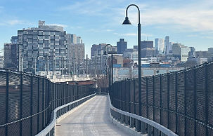
2.3 miles - After biking under Route 28, and crossing above Washington St., pass the East Somerville Green Line station and begin the elevated 0.4 mile portion of the Somerville Community Path - 40 ft high bridge over the MBTA commuter rail and Green Line trolley tracks with excellent views of Boston from the viaduct. Pass “Brickbottom”, one of the first large artist cooperative living studios in the area.

2.9 miles - after the ramp over the RR tracks comes back down to grade, the MCRT re-enters Cambridge for 0.4 miles, and is a multi-use path alongside Morgan Ave. through a large new development (that was once a huge rail yard) called Cambridge Crossing (restaurants, “Central Park”, parking, Orange and Green Line stations).
3.4 miles - Bike either way around the modern 10-story EF.Hult Building and enter North Bank Park, built as mitigation for the Big Dig. Cross the beautiful North Bank bridge over Miller’s river and all the rail lines leading north from North Station.


3.7 miles - When down off the bridge and in Paul Revere Park, you are now in the Charlestown section of Boston. To get to the actual end of the MCRT at North Station (restaurants, commuter rail, Orange Line, Green Line, Celtics, Bruins), you can walk your bike across the Charles River Locks at mile 3.9.
Proceed under the brand new North Washington bridge, another route to downtown Boston, including all the great Italian restaurants of the North End.
4.1 miles - Bike through the historic Charlestown Navy Yard, following the Harbor walk along the waterfront, where the world’s oldest commissioned warship, the USS Constitution, is docked and can be visited with its small but interesting museum at mile 4.4.
Continuing East, you’ll see the wonderful adaptive use of the shipyard building for housing, yacht clubs, retail and hospital research re-use.


5.4 miles - Beautiful views of Boston Harbor, especially at the eastern end at Spaulding Hospital and Menino Park.
5.8 miles - At the end of 16th St., cross Chelsea St. on a crosswalk to a switchback ramp and start traveling north along the Mystic River. There’s a short on-road section on Medford St. Take a detour left on Monument St. (Mile 6.1) if you want to see the Bunker Hill Monument.


7.1 miles - At Sullivan Square, after passing the historic, reused Schraft Candy building, there’s a tricky roundabout to maneuver counter-clockwise. There are bike lanes and crosswalks, so feel free to walk instead of cycling.
7.2 miles - Continue north on Main St. (in the bike lane or sidewalk)


7.3 miles - Take the shared-use path that starts on the right (along Grand Union Blvd.) at a brick wall sign announcing you are entering the Assembly Square/Row area, a huge new mixed use development with plenty of restaurants, an AMC theatre and shopping worth a visit (Legoland & Orange line subway stop also).
8.1 miles - After passing this development, keep on the path along the Mystic River and stay right at 8.4 miles onto the boardwalk under the Route 28 bridge.


Keep cycling with the Mystic R. to your right while passing the Blessing of the Bay boathouse at Mile 8.9 and continue straight into the City of Medford.
9.6 miles - Arrive at this cycling “cloverleaf” where you can choose one of 3 ways to navigate the Mystic R. crossing - the one shown here and in the route seems safest.
10.0 miles - Continue north with the Mystic River on your left though another section of the Mystic R. reservation.
10.5 miles - Continue onto a brand new path section called the Clippership Connector. This name comes from the fact that in the 1800s, Medford was famous for clippership building, over 500 ships built in this area on the Mystic River.
10.8 miles - pass under Interstate 93 and into Medford Square with many restaurant options (Ice Cream too).
Follow this map to follow the Mystic River Path signs along Route 16.

12.3 miles - Cross Route 16 and the Mystic R. near a Whole Foods location and bike along the Path between Route 16, and the Mystic River.
12.7 miles - Carefully follow this route to continue south along Alewife Brook to the south, turning left to cross Mystic Valley Parkway at a light - NOT continuing on the path along the Mystic River to the northwest. Continue on the Alewife Brook path south, next to the parkway.
13.9 miles - Cross Mass Ave. and turn right to cross Alewife Brook, entering Arlington. Immediately turn left to follow Boulevard Rd./Lafayette St. (or the parallel stone dust path closer to Alewife Brook).


14.2 miles - Road ends and continue straight onto dirt path. and onto a boardwalk
14.5 miles - Turn left onto the well-known Minuteman Bikeway (another wonderful rail-trail to the northwest for 11+ miles).
14.6 miles - Turn left onto the MCRT where the Minuteman Bikeway was given an award in 2008 and inducted into the Rail-Trail Hall of Fame. A total of 5 off-road bike/ped intersections near here allow safe cycling in all directions.
14.7 miles - Turn right and follow the map below as the MCRT path jogs around the MBTA Red Line station and garage, through athletic fields to reach a detour along low-traffic Dudley St. (the MCRT here is under reconstruction) and fenced off.

Mile 15 - Cross Massachusetts Ave., turn right along the sidewalk and follow Shea Rd. and Kingston St. to reach the MCRT again and proceed east, crossing Buena Vista St. into Seven Hill Park and Davis Square. The MCRT route continues around either side of the Red Line subway entrance, crossing Holland St. to reach the small park where the route began.

Other Maps and helpful sites:
MassTrailTracker (and the next segment East) – Shows the MCRT segment through Somerville (and Cambridge on both ends). This includes a temporary detour for the “Linear Path” west of Somerville where the route is being rebuilt in 2026.
Here’s a 2023 video by a cyclist on the first day that the new section of the Somerville Community Path along the Green Line extension was opened.
There are numerous places to get food and drink along the Path in Davis Square, Somerville.
For more information on the MCRT in Somerville: Community Path Facebook page