
MCRT: Barre

About MCRT Barre
Barre is a rural agricultural town close to the center of Massachusetts, formed in 1776. Besides agricultural products, the mills of Barre produced farm equipment, palm leaf hats, and gunpowder. A large foundry and precision machining company still operates in Barre, and it has a large Town Common surrounded by Colonial-era buildings, with several restaurants and stores. A portion of the Ware River is diverted into a tunnel in Barre, supplying water to the Boston metropolitan area.
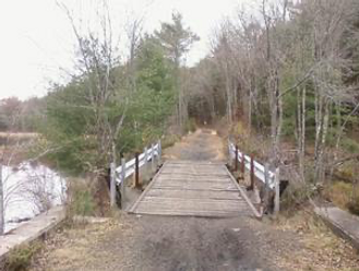
Development of the MCRT in Barre began when Wachusett Greenways constructed the eastern 0.6 miles of MCRT and a bridge over the Ware River in March 2013. At the West end of the MCRT in Barre, the East Quabbin Land Trust acquired the Tanner-Hiller airport and adjacent MCRT corridor in 2024. The Land Trust will be developing a rail trail on this parcel, with 1.2 miles in Barre. There are proposals to close the remaining 2.7 mile gap between these 2 sections by establishing rail with trail, using pathways through Water Department and former town dump land, and some on-road travel.
Visiting the MCRT in Barre
Access Points:
-
McEvoy Rd (New Braintree) – Parking at end, visitors can walk North on Airport Road and see the MCRT corridor. The North end of this section is accessible from the intersection of Station Road and Airport Road in Barre (limited on road parking).
-
1035 Worcester Rd., Barre – Powder Mill Pond parking lot – access for the Eastern (open) Wachusett Greenways section of the MCRT that continues East through Oakham and Rutland.
Additional Resources
Connecting Trails:
The Ware River trail is a 15-mile dirt path through woods and fields, next to the Ware River, following an old railbed. The Southern end is 0.25 miles East on Worcester Road from the MCRT crossing over the Ware River (east of Powder Mill Pond). It continues North from this location to Athol, MA.
Suggested Itinerary:
Riders with mountain bikes and walkers can start at the Tanner Hiller Airport, at the northern end of McEvoy Rd in New Braintree, and travel northeast on the MCRT corridor (old runway and dirt road) for 2 miles to Station Road, where the MCRT corridor ends.
Road bikes can follow an alternative route (below) through Barre that begins at the Hardwick town line on rt 32. (850 Wheelwright Rd, Barre)


For those interested in the Ware River trail, the entrance is 0.7 miles east on rt 122 from the entrance to the MCRT Ware River bridge.
The MCRT continues up the side of a hill with several switchbacks, offering excellent views of the Ware River below. The trail continues east to Oakham and Rutland, on sections built and maintained by Wachusett Greenways.
Nearby sights:
Barre Town Common – Large town common surrounded by historic buildings, shops, restaurants, 3.2 miles north of the MCRT
Rockingstone Park – Two large glacial erratic boulders balanced on top of each other, located 3 miles west of Barre Common on rt 32, on Rockingstone Road.
RideWithGPS Route (Road Route) - https://ridewithgps.com/routes/53618159
Trail Guide (West to East)
Mile
0.0 mi – Barre/ Hardwick Town Line
1.1 mi - Bear right to continue on rt 32 north. To reach Barre Common, with stores, restaurants and historic buildings, instead continue straight here for 3.2 miles.
1.6 mi - Turn left to continue on rt 32 north, convenience store at this intersection. This is part of the village of Barre Plains, once a bustling industrial and transportation center, with extensive woolen mills and several hotels for travelers.
2.3 mi – Continue straight on Vernon Street (don’t turn right on rt 32).
3.3 mi – Turn right onto Route 122
3.8 mi – Turn right onto the path next to rt 122, follow it 0.3 miles to a right turn onto the MCRT bridge over the Ware River. The MWRA Ware River water intake and dam is 0.3 miles east on the MCRT, visible from the trail.

Current MCRT Projects in Barre
Development of the Tanner-Hiller airport and adjacent areas of the MCRT as a stone dust trail by the East Quabbin Land Trust, in partnership with the Mass Division of Fisheries and Wildlife.
Development of rail with trail in Barre Plains by EQLT, with Mass Dept. of Transportation and the Barre Water Dept, next to Vernon Ave.
Evaluation of a potential route from Barre Depot Rd to the MCRT in Oakham using former MCRR right of way or other established trails, by Wachusett Greenways.
A Brief History of the MCRT in Barre
The Ware River runs close to the Southeast border of Barre from the Oakham town line, through South Barre, and continues Southwest into Hardwick. The Mass Central Railroad was built along this river valley, and began operations through Barre in 1886, with trains from Northampton to Boston in 1887. Passenger service ended in 1932, and the hurricane of 1938 destroyed much of the railroad infrastructure along the Ware River, leading to the end of MCRR service in Rutland and parts of Barre. Some of the former MCRR right of way near South Barre was merged with the nearby railroad currently operated by the Mass Dept. of Transportation.
For more information on the MCRT in Barre

The MCRT in Barre is developed and managed by the East Quabbin Land Trust and Wachusett Greenways in cooperation with the Town of Barre and the Massachusetts Department of Conservation and Recreation Watershed Division.
The East Quabbin Land Trust continues to make progress in assembling the MCRT corridor in Barre. Learn more about their work at eqlt.org . Donations are welcome – visit https://eqlt.org/support/
Volunteers for EQLT are encouraged to sign up at https://eqlt.org/about-us/volunteers/ - there are many great opportunities to help complete and maintain the MCRT.

Wachusett Greenways has successfully developed and maintains the easternmost section of the MCRT in Barre, and is seeking to develop the next section of MCRT going west.
Learn more about their work at https://www.wachusettgreenways.org/wordpress/. Volunteers are encouraged to help with trail maintenance and other activities – see. https://www.wachusettgreenways.org/wordpress/about-us/volunteer-opportunities/
Donations support maintaining and completing the MCRT in central Massachusetts – see https://www.wachusettgreenways.org/wordpress/support-us/
Explore Other Communities Along the MCRT
Geographical west to east
Northampton Hadley Amherst Belchertown Palmer Ware Hardwick New Braintree Barre Oakham Rutland Holden West Boylston Sterling Clinton Berlin Bolton Hudson Stow Sudbury Wayland Weston Waltham Belmont Somerville Cambridge Boston
For each MCRT town, we’ll connect you with maps, resources, suggested routes and trail status.