MCRT: Hudson


About MCRT Hudson
Hudson is noted for its award-winning downtown. Check out the many restaurants, shops and brew pubs along Main and South Streets, or the restaurants and shops in the Landing at Hudson Mills. There are many events—indoor and outdoor music venues, street festivals and farmers' markets throughout the year.
The MCRT runs through Hudson for just over six miles. Hudson's section begins at the three-town marker, roughly one mile west of Dutton Road in Sudbury, where the towns of Hudson and Sudbury, and the city of Marlborough meet.
Continuing west, the trail passes through state and town forests, then by Charter Oak Country Club before a ¾ mile-long industrial section crossing Main Street. Beyond this, it crosses the reconstructed Fort Meadow Brook bridge (Bridge 130) and passes through the new Chestnut Street underpass.
Visiting the MCRT in Hudson
Access Points:
-
Old Central St (near I-495) and Rt 62 commuter lot - limited parking
-
27 South St parking lot (near ARRT trail)
-
Villa do Porto Blvd., on -street parking (next to ARRT trail)
-
Main St parking lot (across from Hatch Motors)
-
Wilkins St Parking Lot (ARRT / MCRT intersection)
-
White Pond Rd / MCRT intersection (limited on road parking at Bruen Rd)
Additional Resources
Connecting Trails:
Marlborough-Sudbury State Forest
There are a number of trails through the Marlborough-Sudbury State Forest which borders the MCRT between White Pond and Parmenter Roads. The trails are not currently blazed. Local trail enthusiasts are working with DCR to blaze the trails and to construct better access and signage from the MCRT.

Assabet River Rail Trail
The MCRT intersects and is contiguous with the Assabet River Rail Trail (ARRT) from the parking lot on Route 62 (Wilkins Street) to the parking lot on Main Street. The ARRT continues beyond that point for 4½ miles connecting to the Old Common Cemetery on Central Street Marlborough—one block from Main Street, which is home to many shops and restaurants.
Riverwalk
Hudson's Riverwalk starts at Cellucci Park on South Street, two blocks west of where the ARRT meets Broad Street. This peaceful riverfront oasis features overlooks and benches, plus a nearby skate park, playground, and splash pad.
Best Access to Downtown Hudson from the MCRT
To reach downtown Hudson, continue on the Assabet River Rail Trail to the Broad Street intersection. Turn off the trail there and proceed two blocks west on South Street to the intersection of South and Houghton Street. Bicycle racks are available just inside Cellucci Park. You'll find various restaurants and shops by continuing west on South Street. Main Street, with a huge variety of shops and restaurants is one block north on Houghton Street.
Suggested Itinerary:
Going from West (Bolton town line) to East (Sudbury town line), the first part of the MCRT route is on busy roads, as the western section is still being designed.
The map above shows the section of the MCRT in Hudson which is currently under design, and a temporary route heading East from open sections in Clinton and the Wachusett Greenways.
This map below shows the current MCRT route through Hudson. Note, this includes on-road sections with heavy traffic and narrow shoulders.
RideWithGPS Route - https://ridewithgps.com/routes/53656594
Trail Guide (West to East)
Mile
0.0 mi – Start at the intersection of Gates Road and Route 62, just East of the I-495 interchange. The first section is in the town of Berlin - to avoid the busy section of Route 62 East of I-495. Continue south on Gates Rd.
1.6 mi - Left on River St
1.7 mi - Enter Hudson
2.3 mi - Right on Rt 62
2.4 mi - Go ¾ around traffic circle, exit to stay on 62 East. Downtown Hudson - many shops, restaurants
2.5 mi - Left on Church Street
2.7 mi - Right on sidewalk perpendicular to Church Street, just after the Senior Center parking lot. This leads to the former MCRT RR trestle over Bruces Pond, this will be part of the MCRT trail in a few years. Walk – don’t ride - bridge may be unsafe.
2.8 mi - Right on Manning St.
3.0 mi - Left on Assabet River Rail Trail. Right turn here on ARRT goes to Marlboro in about 2 miles, with a nice crossing of the Assabet River and overlook above the Fort Meadow Reservoir.
3.2 mi - Carved and welded sculptures on the left, then a fish xylophone on the right near an old caboose. Parking lot nearby.
4.0 mi - Mural depicting Hudson history, bridge over the Assabet River, then follow the trail across Route 62 at a pedestrian light.
4.5 mi - The MCRT shares the Wilkins Street (Route 62) parking lot—which is also the trailhead for the Hudson to Marlborough section of the Assabet River Rail Trail. MCRT continues across the street. Careful crossing this busy street - pedestrian warning signals aren’t yet installed.
5.0 mi - MCRT goes through a part of Stow MA for about 250 feet, then back to Hudson
5.2 mi - Chestnut St tunnel
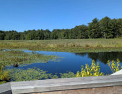
5.4 mi - Fort Meadow Pond bridge - spectacular wildflowers in spring, summer and fall. Look for birds. Entering an industrial area for the next mile.
6.1 mi - Cross Main St - Careful crossing this busy street - pedestrian warning signals aren’t yet installed. Next, the Charter Oak Country Club golf course on the right.
6.6 mi - Cross Parmenter St. Lake Boone General store is at the northern end of this street, about 0.3 miles.
6.8 mi - Trail on left goes through Marlboro State Forest,
7.4 mi - Cross white Pond Road
7.8 mi - Enter Sudbury - obelisk where 3 town lines meet (towns of Hudson, Sudbury and city of Marlboro)


Current MCRT Projects in Hudson
The section from the Main Street parking lot to the Berlin town line is under design. This right-of-way of the former Central Massachusetts Railroad is owned by the MBTA. DCR holds a 99-year lease to construct a multi-use path along this corridor. The Town of Hudson received a Mass Trails grant in 2023 to develop a 10% design for the path on this section of the trail. Here is a detailed map of this 3-mile section.
Hudson received a FY2026 Surface Transportation Block Grant to cover 100% design of the section from the Main Street parking lot to Felton Street (which is just off of the rotary at the intersection of routes 62 and 85).

This section will require the replacement of the bridge over Tower Street, the underpass under High Street; and either refurbishing or replacing the bridge over Bruce’s Pond.

The Town also received a FY2026 Mass Trails Grant to complete a 25% design for the section of the trail from Felton Street to the Berlin Town Line.
A Brief History of the MCRT in Hudson
Indigenous peoples inhabited the area along the Assabet River and its tributaries which is now known as Hudson. Colonial settlers arrived in 1650, and the first mill was built in 1698 when the area was part of Marlborough. In the early 19th century, Hudson became known for shoe manufacturing, at one time home to 17 shoe factories. After two railroad lines arrived in the 1850s, diverse industries followed—woolen mills, elastic-webbing plants, piano case factories, and rubber-coating fabric factories. Hudson separated from Marlborough and was incorporated as a town in 1866.
The first three miles were completed by the Massachusetts Department of Conservation and Recreation (DCR) in Fall 2025, built atop an underground Eversource high-voltage transmission line.
For more information on the MCRT in Hudson
Hudson’s rail trails have been developed through a partnership among various Town committees, DCR and other agencies. The main coordinating group is the Ad-Hoc Bicycle and Pedestrian Committee, who continue to advance a vision of a safe and walkable town infrastructure.
Explore Other Communities Along the MCRT
Geographical west to east
Northampton Hadley Amherst Belchertown Palmer Ware Hardwick New Braintree Barre Oakham Rutland Holden West Boylston Sterling Clinton Berlin Bolton Hudson Stow Sudbury Wayland Weston Waltham Belmont Somerville Cambridge Boston
For each MCRT town, we’ll connect you with maps, resources, suggested routes and trail status.