
MCRT: Clinton


About MCRT Clinton
Historically, Clinton developed as an urban industrial town, with mills located along the Nashua River. The overall landscape of Clinton is characterized by steep slopes, forested outskirts, and water resources including the Nashua River, Counterpane Brook, Clamshell Pond, a network of connected ponds in the southwest corner of town, and the Wachusett Reservoir. Clinton offers residents convenient proximity to natural features, neighborhoods, parks, and public space.
The Clinton Section of the MCRT runs from the Sterling town line to the Berlin town line. Note: the former Central Massachusetts railroad is still an active rail line from Sterling to West Boylston. MCRT Clinton arguably includes some of the most interesting features of the trail, with a 1,110-foot tunnel and the Wachusett Reservoir and Wachusett Reservoir Dam.
The MCRT Clinton is open for bicycle riding, hiking, and walking from Gate 39 of the Wachusett Reservoir to Gate 43. Bicycles are allowed on the former rail bed. Bicycles are not allowed on the north Dike of the Reservoir – please follow this rule. The MCRT Clinton is also open for walking between the Rauscher Farm and the Woodlands. Current access to the trail is from a grass path on the Rauscher Farm and a narrow board onto the trail. This section is not currently suitable for bicycles.
Visitors on the MCRT-Clinton section adjacent to the Wachusett Reservoir will see loons, red tailed hawks, and other birds. You may also spot eagles, fox, and mink. Visit High Street in Clinton for shops and restaurants. The world-renowned Icon Museum is at 203 Union Street.
Visiting the MCRT in Clinton
Access Points:
-
Gate 39 of the Wachusett Reservoir, parking at South Meadow Road and Route 110 (West Boylston Street)
-
Gate 43 at River Street and Route 62 (Chestnut Street, Boylston Street) no parking at this location
-
Rauscher Farm in Clinton
-
Parking at 29 Clamshell Road
-
MCRT Clinton is accessed via the grass path behind the old farm house
-
Not currently suitable for bicycles
-
Additional Resources
Connecting Trails:
The MCRT Clinton between Rauscher Farm and the Woodlands connects to many trails around the Rauscher Farm and the Woodlands. The Lancaster Mill Rail Trail is another planned trail that will connect to the MCRT near the bridge over the Nashua River.
Suggested Itinerary:
Drive, ride, run, or walk to Gate 39 of the Wachusett Reservoir. Access to the trail is also available at Gate 40 (at the end of South Main Street. Mileage is noted with each map section. Gate 39 to the MCRT Clinton section at Rauscher Farm is 8.56 miles round trip. You can do much shorter itineraries by doing a section or turning around at any point.
-
Gate 39 to Gate 43
-
Follow the StoryMap Gallery for details on this path DCR-DWSP StoryMap Gallery, enjoy the view of the Wachusett Reservoir and the Wachusett Reservoir Dam. Mileage marker B36, N68 is not far from Gate 39.
-
-
Turn right on Boylston Street and pass the dam on the right (big hill)
-
Turn left on Wilson Street (more hill)
-
Turn right on Clamshell Road – this brings you to the Rauscher Farm and Clamshell Pond. There are many walking trails around the farm including the path to the MCRT – Clinton. There are many walking trails around the farm including the path to the MCRT – Clinton.
If you have started at South Meadow Road and Route 110, there is also a walking trail that leads to the former station. This trail eventually meets the active railroad, currently operated by CSX (trains travel at high speed, so stay off the tracks!)
Do not miss downtown Clinton! Instead of turning right at Boylston Street, turn left onto Chestnut Street, follow this to Mechanic Street and then Union Street (the Icon Museum is at 203 Union Street) and then turn right onto High Street for lots of options for shops and restaurants.
RideWithGPS Route - https://ridewithgps.com/routes/53661621
Trail Guide (West to East)
Wachusett Reservoir and the Wachusett Reservoir Dam.
For a short hike, take Gate 39 to the top of the Dam - 2.5 miles or turn around at any point for a shorter walk/ride.

Photo credit Martinde
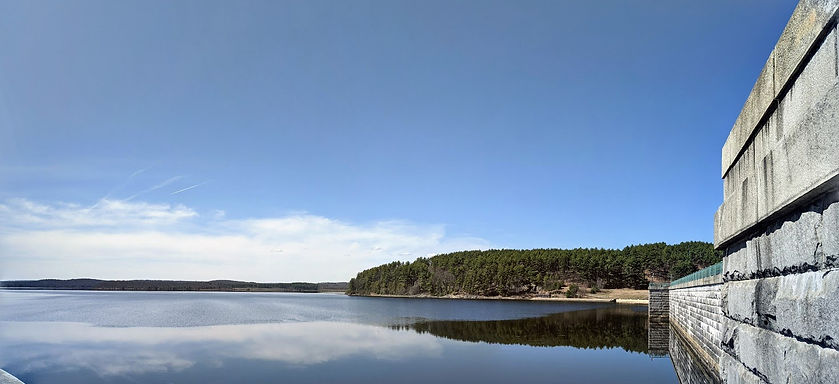
Photo credit: Gageills
See Rauscher Farm, a short 1.18 miles from the Wachusett Reservoir Dam.
Then, Rauscher Farm to the MCRT Clinton Trail is a quick 1.2 mile round trip.

Photo credit: Heidi Notaro
Current MCRT Projects in Clinton
The build phase of the MCRT Clinton from the Rauscher Farm to the Berlin town line is in progress with construction planned for the Spring / Summer / Fall of 2026. This phase will include accessible parking and trail access from two locations - the Rauscher Farm and the Clinton Greenway Conservation Trust Trailhead at 447 Berlin Street.
The design for the remediation of the tunnel was completed in 2023. Work on the remediation of the tunnel is dependent on the completion of a design for the crossing of Route 70 and joining the existing trail around the Wachusett Reservoir.

A Brief History of the MCRT in Clinton
Originally conceived in the 1870s as a link between Boston and the west, the Central Massachusetts Railroad became Boston & Maine's longest branch line, stretching 104 miles Westward to Northampton. One of the last railroads to be built in the state, it was ill-fated from the start, facing stiff competition from two highly prosperous and well-established lines, as well as from the rise of the automobile. In the end, the railroad fell victim to a changing economic environment, the Great Depression and various natural disasters which wreaked havoc on the line.
By the 1890s, the City of Boston and surrounding communities were facing a crisis. Current water supplies were growing insufficient for a metropolitan area which was experiencing significant population growth. They looked West for solutions and one was found which would have a profound effect on the young railroad.
In the summer of 1895, a law was passed which authorized the Metropolitan Water Board to construct a reservoir in the valley of the South Branch of the Nashua River within the towns of Clinton, Boylston, and West Boylston. This massive undertaking would require relocating West Boylston, removing mills, schools, churches and 360 homes in the process. West Boylston's Old Stone Church remains as a lone reminder of what was lost. In addition, seven miles of the Central Massachusetts Railroad would have to be rerouted. Thus began one of the most ambitious civil engineering projects of its day. The Wachusett Reservoir ended up being the largest public water supply in the world at that time. The Wachusett Dam is still the largest hand-dug dam in the world.
The agreement between the Metropolitan Water Board and the Boston & Maine detailed the relocation of the railroad around the north end of the new reservoir. In another amazing engineering feat, the plans called for the construction of a 1,110 ft. tunnel, immediately followed to the west by a 917 ft. trestle bridge which towered 133 ft. above the Nashua River. For travelers on the railroad, this was one of the most spectacular and scenic sections of the line. The tunnel remains today and the bridge survived until 1975.
Both freight and passenger service continued to Clinton during the first half of the 20th century but dwindled steadily as traveling by train fell out of favor. By 1949, service was reduced to just one freight run a day. In 1956, the last steam-powered train left Clinton bound for Boston.
There is nice write-up of the railroad and the rail trail in the DCR kiosk at Gate 39.
For more information on the MCRT in Clinton
The Clinton section of the MCRT is managed by the town of Clinton, the Clinton Greenway Conservation Trust, and DCR Watershed.

To learn more about the CGCT projects and to volunteer, visit https://clintongreenway.org/our-work/
Explore Other Communities Along the MCRT
Geographical west to east
Northampton Hadley Amherst Belchertown Palmer Ware Hardwick New Braintree Barre Oakham Rutland Holden West Boylston Sterling Clinton Berlin Bolton Hudson Stow Sudbury Wayland Weston Waltham Belmont Somerville Cambridge Boston
For each MCRT town, we’ll connect you with maps, resources, suggested routes and trail status.