
MCRT: Sudbury


About MCRT Sudbury
Sudbury is a former agricultural town, known best for the historic Wayside Inn and Grist Mill, and the Great Meadows wildlife refuge on the Sudbury River.
The MCRT goes through Sudbury for 4.3 miles, passing across miles of wetlands, a unique pine barren forest, and is close to the commercial center of the town. Visitors on the MCRT might see blue herons and other birds, wildflowers, turtles, and glacial features from the last ice age. At the town commercial center, there are plenty of places near the MCRT for a drink or bite to eat, with indoor and outdoor seating. Historical features along the MCRT include the old Sudbury train station, the Section Toolhouse, the Diamond Crossing with the Bruce Freeman Rail Trail, and within a few miles, you can visit the Wayside Inn and the historic Town Center. The Sudbury section was developed and is now managed by DCR in partnership with the Town of Sudbury as part of the MCRT Wayside section. It is not yet officially open, and street crossing signals are not yet installed, so please be careful.
Visiting the MCRT in Sudbury
Access Points:
From Hudson, continuing east on the MCRT -
-
Bruce Freeman Rail Trail intersection (a few space nearby, more parking 1.5 miles North at Town Center)
-
Union Ave / MCRT intersection (parking nearby along Station Ave)
-
Eversource driveway / MCRT intersection (no parking)
Additional Resources
Connecting Trails:
At the western end of Sudbury, many walking trails through Memorial Forest, the Assabet National Wildlife Refuge and Hop Brook Marsh. Learn more here.
In the middle of the Sudbury section, the southern end of the Bruce Freeman Rail Trail intersects the MCRT – a paved path that extends 22 miles north through West Concord (MBTA rail station), Acton, Carlisle, Westford, Chelmsford and ends in Lowell. The Sudbury section of the BFRT is not yet officially open, and not yet maintained by the Town, but the Mass DOT does permit usage, so please be careful.
Suggested Itinerary:
Traveling the MCRT from West to East, this 8-mile route is a great tour of Sudbury from the trail.
RideWithGPS Route - https://ridewithgps.com/routes/53484157
Trail Guide (West to East)
Mile
0.0 mi – Sudbury section starts where the town lines of Sudbury, Marlborough and Hudson meet.
0.6 mi – trails south to Memorial Forest – pine barrens, ‘desert’ area (see https://www.svtweb.org/properties/page/memorial-forest-sudbury) and north to Hop Brook Marsh (Town of Sudbury)
0.7 mi – Hop Brook wetlands
1.0 mi – Dutton Rd crossing – former Wayside Inn train stop. Babe Ruth, who lived nearby, traveled to Boston from here. (Wayside Inn is 2 miles south on Dutton Rd)
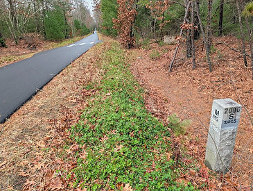

1.9 mi - on the left, old granite mile marker " B21/ N83 " - this was 21 miles from North Station, Boston and 83 miles from Northampton on the Mass Central RR

3.0 mi – Sudbury Station, Diamond crossing with Bruce Freeman Rail Trail (historic Town center is 1.5 mi north)
3.05 mi – Union Ave – coffee shop, food stores, restaurants ¼ mile south (caution- busy road!). (visit Google Maps to see nearby businesses)

3.2 mi - Section Toolhouse (see. https://sudburyweekly.com/proposed-acquisition-of-historic-railroad-buildings-could-present-business-opportunities/)

3.5 mi – Hop Brook crossing, extensive wetlands – look for birds and flower, and large turtles laying eggs in the spring.
4.3 mi – Eversource lot at Sudbury - Wayland town line.

Current MCRT Projects in Sudbury
Developing signage to guide visitors to places to eat and shop, and enhancing accessibility for connecting trails.
A Brief History of the MCRT in Sudbury
The Mass Central railroad started here in 1885, and last operated in the late 1970s. In 2022, an Eversource / DCR project began, placing an underground power line from the Wayland substation to Hudson, reconstructing several bridges, and paving the path over the power line. The project will be completed by spring 2026. The section from the Wayland town line to Wayland Center, about 1.6 miles, will be completed in 2028 (see https://www.mass.gov/event/sudburywayland-rail-to-trail-project-2023-03-02t180000-0500-2023-03-02t193000-0500).
For more information on the MCRT in Sudbury
Explore Other Communities Along the MCRT
Geographical west to east
Northampton Hadley Amherst Belchertown Palmer Ware Hardwick New Braintree Barre Oakham Rutland Holden West Boylston Sterling Clinton Berlin Bolton Hudson Stow Sudbury Wayland Weston Waltham Belmont Somerville Cambridge Boston
For each MCRT town, we’ll connect you with maps, resources, suggested routes and trail status.