
MCRT: Holden


About MCRT Holden
Holden, incorporated in 1741, was a small farming town North of Worcester. With ample water power and two railroads with multiple stops in town, numerous mills with immigrant mill villages developed during the 1800s. Prominent hotels welcomed tourists and offered respite from the city heat in the beautiful rolling hills. During the 1900s, most of the mills were removed during the development of the Wachusett and Quabbin Reservoirs. Now Holden is a thriving town with community-engaged residents, ample open space, protected watershed, recreational programs and business services. Learn more, Holden Historical Society.
The MCRT in Holden
Wachusett Greenways stewards the Mass Central Rail Trail in Holden. The 1.5-mile portion from River Street to I-190 at the West Boylston line is on the old Mass Central Railroad line along the Quinapoxet River. In other areas, the railroad was sold after service ended in the 1930s. An additional 6 miles of the MCRT is now complete using other land to carry the trail West to Princeton Street. Wachusett Greenways developed the trail from 1999-2025 in collaboration with DCR DWSP, the Town of Holden, the Kaplan family, RTP, MassTrails, and regional towns. Wachusett Greenways and partners continue construction planning to close the gap going West to Rutland at Route 68.
Visiting the MCRT in Holden
Access Points
Princeton St. (across from 407 Princeton St.) Parking for two or three cars.
Near 103 Mill Street. Parking with portable accessible year-round restroom.
Additional Resources
Mill Street at Route 31 (Wachusett St.) Larger parking area here.
Manning Street (See flashing crosswalk sign. Near 200 Manning Street.) Large parking area.
River Street. (Just beyond small horse farm at 300 River Street.) Parking with portable accessible year-round restroom, bench and kiosk. Picnic tables along Quinapoxet River at bridges— at 0.2 miles and 1 mile.
Suggested itinerary and sights to see
The route through Holden includes both temporary on road segments as well as segments of completed MCRT trail. It begins at the Rutland town line with a suggested on-road segment to the Princeton Street entrance to the MCRT.Traveling the MCRT from West to East in Holden
Note: Red = temporary on road route; green = MCRT trail and designated road route
Trail Guide (West to East)
Mile
0.0 - Begin at the Holden / Rutland town line – at the end of a short, very rough,
unconstructed incline leading from the East end of the MCRT trail in Rutland onto Route 68. Continue South on Route 68 – caution: busy road with high-speed traffic.
[Alternate: Begin in Rutland at Wachusett St MCRT parking. Ride to blinking light at Route 68, turn right to continue downhill on Route 68 past the Rutland/Holden town line]
0.7– Take a sharp left onto Bryant Road, and ride uphill, continues as Whitney Street.
2.7– Sharp left onto Princeton Street.
3.2– Pass Maple Spring Pond on the right, a popular and scenic fishing and canoeing destination, then cross the active P&W railroad line, continue uphill, pass a bar gate on the right for old Cobb Street.
Now begin the MCRT on-trail route:
Mile
0.0 - Opposite 407 Princeton Street, go right at a metal gate and two-car parking lot onto the start of the MCRT trail in Holden.
0.2 – Enter old Cobb St., then bear right at a large, flat, perched stone bench. (don’t go straight on the dirt road)
0.5 –Trail joins the old MCRR railbed, turning to the left.
1.6 – Descend a series of switchbacks to the Mill St. parking lot and accessible portable restroom.
2.0 - Turn left onto Mill St. to stay on this scenic on-road section of the MCRT through a quiet neighborhood.
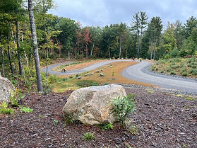
2.6 – Cross Wachusett Street at an MCRT parking lot, continuing on the newest section of the MCRT in Holden, up a series of switchbacks to the top of the hill.
3.5 – The trail goes alongside a farm with a clear view across a field to the north. Please stay on the trail here – this is private property.

3.7 – Begin a series of switchbacks descending to the Manning St parking lot
5.0 – Carefully cross Manning Street at the flashing light crosswalk with an activation button and continue on the MCRT. [The Trout Brook reservation is 0.3 miles East on Manning Street].
5.8 - At River St. there is a parking lot and accessible portable restroom. Make a U-turn to the left down a short slope to the rail bed. Now you are on Wachusett Greenways’ Springdale Mill River section of the MCRT through Holden.
6.0 - Cross the Quinapoxet River on the Jeremiah Kaplan bridge.

In May watch for pink lady slippers, the MA native protected orchids.

6.8 - Cross the Quinapoxet River a second time on the Charlotte Kaplan bridge. A group of four benches in honor of the Kaplan family are located near native azaleas which are fragrant in the spring.

7.0 - Sign on the right for the Springdale Mill Historic Interpretive Site. Park your bicycle at the rack and follow a self-guided tour through the mill site and mill housing village.

Major Isaac Damon reported in 1879: “One of the most attractive mills in Holden — Spring Dale Mill — was built in 1875–76, by Mr. L. J. Smith of West Boylston. It is situated on the Quinapoxet River, a short distance from the West Boylston line. It is built of granite quarried near the mill, contains three sets of machinery, and manufactures about two hundred and fifty thousand yards of fancy cassimeres annually, furnishing employment for thirty-five hands”.
At the bottom of the Springdale Mill dam wall, is the entry to the race which carried water from the mill pond to power the mill. The Quinapoxet River is just to the right.
7.5 miles - Pass under the I-190 bridge, over 120 feet above the trail, at the Holden/West Boylston town line.

For more information on the MCRT in Holden

Wachusett Greenways is constructing and maintains the MCRT in Holden, in partnership with DCR DWSP, and with support of Mass Trails grants. In 1995 Holden Greenways Task Force volunteers first envisioned an amazing community trail on the old Mass Central Railroad corridor. The vision quickly expanded to form Wachusett Greenways, a volunteer non-profit group, to connect the region with the Mass Central Rail Trail.
Visit the Wachusett Greenways website to volunteer, participate, or contribute.

Wachusett Greenways dedication for the new Manning Street / Wachusett Street section of the MCRT, 2025
Explore Other Communities Along the MCRT
Geographical west to east
Northampton Hadley Amherst Belchertown Palmer Ware Hardwick New Braintree Barre Oakham Rutland Holden West Boylston Sterling Clinton Berlin Bolton Hudson Stow Sudbury Wayland Weston Waltham Belmont Somerville Cambridge Boston
For each MCRT town, we’ll connect you with maps, resources, suggested routes and trail status.