MCRT: Northampton

About MCRT Northampton
Northampton, located in the “Pioneer Valley” area of West-central Massachusetts, offers a lifestyle rich in cultural, artistic, academic, and business resources. The downtown center is one of the most vibrant in New England.
The MCRT in Northampton
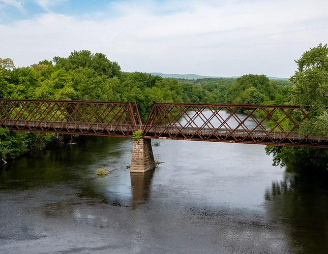
The MCRT starts at Mile “0” in Northampton at Union Train Station. Heading East on the Norwottuck Rail Trail is approximately 1.8 miles long to the Hadley town line. The route travels through neighborhoods and crossing streets, through wooded residential areas until the iconic bridge over the Connecticut River, at approximately 1.4 miles.
Visiting the MCRT in Northampton
Access Points:
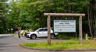
Parking is available at Connecticut River Greenway State Park, 136 Damon Rd, Northampton, MA 01060
Public Transportation
-
By Bus: Visit the Pioneer Valley Transit Authority to see the schedule of buses in the area.
-
By Train: AMTRAK runs service through Northampton
Additional Resources
Trail Guide (West to East)
Suggested Itinerary and Sights to See
Mile
0.0 mi - Northampton offers a vibrant downtown area. There are many restaurants, stores and people in the downtown area. The Manhan Rail Trail continues south from here to Mt Tom and Easthampton.
0.7 mi - Connection to the Northampton Rail Trail, which continues to Florence and Leeds villages for a total of 2.5 miles.
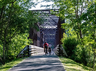
1.4 mi - Connecticut River Greenway State Park - Walk or ride across the Connecticut river on the restored railroad bridge.

Alternative Routes
This pleasant 8-mile ride starts in Northampton and ends in Amherst, providing a easy connection between two bustling college towns. If you are looking for additional miles, continue on the trail until its eastern end in Belchertown, and optionally take the trail all the way back to Northampton for a 24-mile out-and-back ride.
An alternative, equidistant return route for the more adventurous: ride South on Warrenwright Road to Orchard Street, then West to and along Bay Road (refuel with Atkins Farm donuts) and across the Hampshire College campus (home to the Eric Carle Museum and the Yiddish Book Center), continuing west along their farm roads (see map), then north on Maple St (cool off with Cook Farm ice cream), and west on (car-free!) Moody Bridge Road (traversing the Conte National Wildlife Refuge) to West Bay Rd, West to West St, and North to the historic Hadley town common (which you already crossed on your outbound ride), and back across the trestle bridge over the Connecticut River to where you began!
A Brief History of the MCRT in Northampton
The Norwottuck Branch Rail Trail was first opened in 1993, connecting Northampton, Hadley and Amherst MA. The railbed started out with the Central Massachusetts Railway in 1887. Click here for more history of the Norwottuck.
Explore Other Communities Along the MCRT
Geographical west to east
Northampton Hadley Amherst Belchertown Palmer Ware Hardwick New Braintree Barre Oakham Rutland Holden West Boylston Sterling Clinton Berlin Bolton Hudson Stow Sudbury Wayland Weston Waltham Belmont Somerville Cambridge Boston
For each MCRT town, we’ll connect you with maps, resources, suggested routes and trail status.